
Live Updates:
Tuesday, 3.45pm
A number of flights have diverted to Shannon Airport as a result of high winds at Dublin and Cork airports.
Ryanair (UK) flight RK-767 from Manchester to Cork diverted to Shannon after being advised that wind speeds at Cork were out of limits for a safe landing.
Aer Lingus flights EI-68 from Los Angeles and EI-52 from Seatle had both attempted to land at Dublin but aborted their approaches and diverted to Shannon instead. This was because of high crosswinds. Winds at Dublin were reported to be gusting at 45 knots (76km/h) and higher at the time.
Roads
Widespread flooding has been reported across Clare this afternoon much of it as a result of heavy rain however some roads are being affected by water run-off from lands.
Power
Just one power outage has been reported in Co Clare with 97 customers being affected.
The fault, in the Ennistymon area of North Clare, was reported at 12.10pm however power was restored at around 3.35pm.
Tuesday, 12.25am
A Ryanair flight from Madrid (Spain) to Shannon has been forced to divert to an airport in the UK as a result of high winds at Shannon.
Flight FR-7921, which was due to land at 10.55am, diverted to Stansted Airport in England after entering a holding pattern north east of Shannon Airport for a time. The crew opted to divert as winds at Shannon have been gusting up to 40 knots (74km/h).
Similar wind speeds have been recorded at Cork Airport which would otherwise have been an alternative diversion airport for the crew.
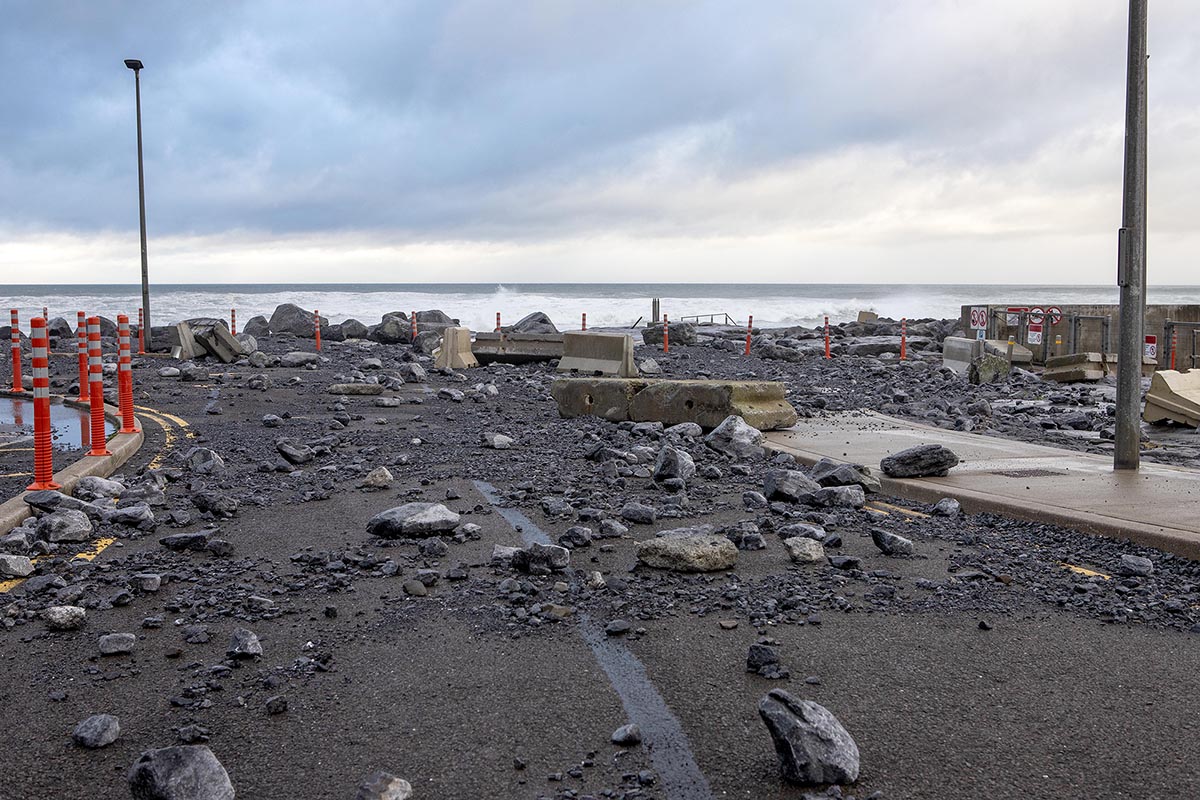
Extensive damage has been caused to the carpark at Doolin Pier in North Clare even ahead of the arrival of Storm Bram.
Big seas in recent days have washed large boulders from the shoreline up into the carpark while a number of concrete bollards, each weighing several tonnes, were also tossed around by big waves.
The carpark has been almost completely covered in gravel and rocks.
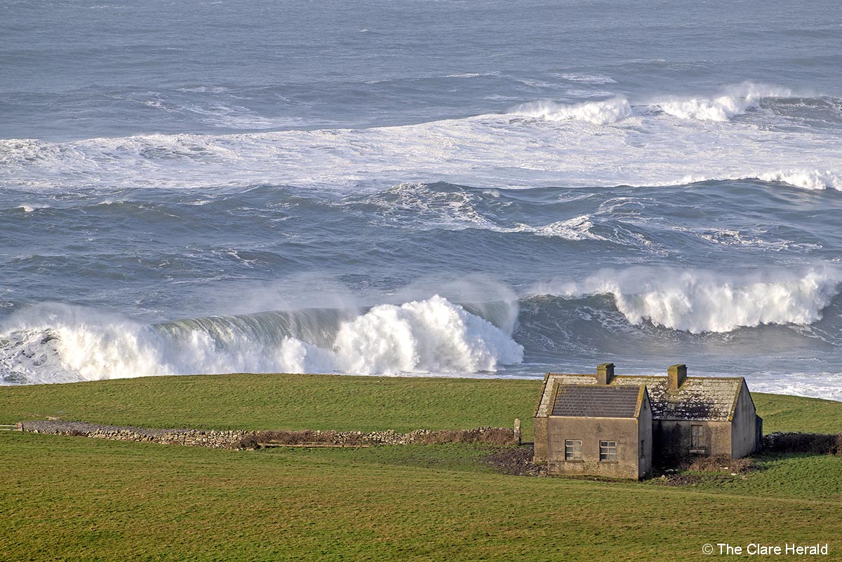
While Co Clare has been under a Status Orange Wind Warning since 11.00am today, a Status Red Storm Warning for coastal areas was due to take effect from midday.
The Storm warning, which will affect areas from Carnsore Point to Roche’s Point to Loop Head will bring South to southwest winds which will occasionally reach violent storm force 11.
Tuesday, 10.47am
This morning’s high tide has passed while next high tide in Clare will be this evening at around 8.30pm.
Winds are picking up and seas are quite big along the Clare coast.
Management at the Cliffs of Moher confirmed that the site would remain closed today.
They have said: “As the safety of our visitors and staff is our top priority, please note that the Cliffs of Moher Visitor Experience will be closed all day Tuesday due to the Orange weather warnings associated with Storm Bram.
Please do not attempt to access the site, conditions are expected to be extremely unsafe.”
Bunratty Castle and Folk Park will also remain closed today.
A spokesperson said: “To ensure the safety and well-being of our staff and visitors, Bunratty Castle and Folk Park will be closed on Tuesday, 9 December 2025, due to the Orange Weather Warning issued by Met Éireann for Co. Clare.
Unfortunately, the Santa’s Grotto Experience will not proceed on this date due to the Orange Weather Warning in place. Our Reservations Team will be in touch with you over the course of the day.”
Shannon Airport has issued a passenger notice advising intending travellers to contact their airline for the most up-to-date flight information.
Just one flight from Shannon Airport has been cancelled this morning. The daily Aer Lingus EI-380 service to London Heathrow will not operate while the return leg, EI-381 has also been cancelled.
Aer Lingus’ flights from Shannon to New York (EI-111) and Boston (EI-135) are scheduled to depart later than scheduled at 4.00pm and 4.45pm respectively.
No power outages reported in Clare yet.
Monday, 10.35am
A Status Orange Wind Warning has been issued for several counties including Clare, Limerick, Donegal, Galway, Leitrim, Mayo and Sligo.
Met Éireann says that Storm Bram will bring very strong to gale force southerly winds with the strongest winds along the coast.
The potential impacts include:
• Flooding of low-lying coastal areas, especially during high tide
• Wave overtopping
• Difficult travel conditions
• Debris, loose objects displaced
• Outdoor events impacted
A Status Yellow Wind Warning had already been issued for all of Ireland. That’s due to come into effect at 3.00am on Tuesday and would have been valid until 10.00pm.
However, the more serious Status Orange alert will begin at 10.00am on Tuesday and remain in place until 9.00pm while the original Status Yellow warning continue to be effective until 10.00pm.
A Status Red – Storm Warning has also been issued for coastal areas from Mizen Head to Slyne Head to Malin Head
South to southwest winds will occasionally reach violent storm force 11.
This warning will be valid from 9.00am until 11.30pm on Tuesday.
The National Directorate for Fire & Emergency Management (NDFEM) convened a meeting of all Local Authorities, relevant Government Departments, state agencies and utility providers today to plan and prepare for Storm Bram. This storm is a multi-hazard event with the potential for significant damage and disruption. Storm Bram will bring very strong to gale force winds, with the strongest winds in coastal areas. Impacts may include coastal, river and surface flooding, wave overtopping, difficult travelling conditions, fallen trees and debris – with potential disruption and to transport services and scheduled events.
Many parts of Ireland have experienced significant rainfall in recent weeks. The forecast rain is expected to arrive in areas where ground levels are already saturated, and many rivers are already at capacity. This brings a significant risk of flooding, particularly in Munster and coastal counties, where the timing of high tides may coincide with strong winds, creating a further risk of flooding. The public is reminded that flooding is a risk for all areas due to the current conditions, and even counties with a yellow weather warning or no weather warning will remain at risk of flooding.
Local Authorities and Transport Infrastructure Ireland will be active and responding to the affected areas as required; however, the need may arise to close some roads due to fallen trees, debris or flooding, and all motorists should follow all traffic instructions put in place. Driving during strong winds or heavy rain is a significant risk, and motorists should take considerable care when travelling, remaining conscious of the road conditions at all times.
The NDFEM will continue to meet throughout this period and will continue to liaise with all relevant Departments and agencies to monitor the situation and to coordinate the appropriate response.
Keith Leonard, National Director of the National Directorate for Fire and Emergency Management, said: “Storm Bram is a multi-hazard weather event – so we’re asking people to be aware of the elevated flood risks and strong winds it will bring. Coastal areas may experience coastal flooding, wave overtopping and storm surge, especially in low-lying locations, so people should keep away from coastal edges, harbours, piers and low-lying promenades, particularly during high tide.
Strong winds can also of course make driving conditions very hazardous, especially for the more vulnerable road users like cyclists, pedestrians, motorcyclists and high-sided vehicles. I would ask road users to make themselves aware of the potential conditions they may face, take extra care, and pay particular attention to the risk posed by fallen trees and flying debris.”
Further public safety advice
Check Local Authorities websites and social media channels for information on road closures, flooding updates, and community alerts.
Follow advice from emergency services and your local authority.
Allow for disruption during Tuesday morning commute – plan extra travel time and reduce speed.
Check in with neighbours, older people or anyone who may need assistance in case conditions worsen.
Stay away from swollen rivers, streams and flooded riverbanks – banks can collapse without warning, water levels and currents may be far stronger than usual.
Do not drive through floodwater – turn back and use another route.
People are advised to prepare for the arrival of the storm including ensuring their mobile phone is fully charged to enable communication.
ESB Networks is highlighting the dangers posed by fallen live wires and is advising the public and the emergency services to stay away from these fallen cables and to report such cases to it immediately. ESB Emergency Services can be contacted at 1800 372 999. The public can monitor www.PowerCheck.ie in regards to power restoration times.
Uisce Éireann customers can check the website and social media channels for updates and to get in touch with any issues or concerns via their 24/7 customer care centre at 1800 278 278. The public can also sign up online to their free text alert system to get regular updates about their local supplies – see www.water.ie.
Sunday, 4.03pm
Met Éireann has issued Status Yellow – Wind Warning for all Ireland this Tuesday.
Forecasters say we can expect “very strong and gusty southerly winds with gales possible near coasts.”
They are also warning of an increased flood risk in coastal areas due to coincidence with very high spring tides.
Possible impacts include:
• Difficult travel conditions
• Flooding of low-lying coastal areas
• Wave overtopping
• Debris, loose objects displaced
• Outdoor events impacted
The alert will take effect at 3.00am on Tuesday and remain in place until 9.00pm (Tuesday).
Clare-based weather information provider WeathÉire says forecast models remain divided on the likely impact of a developing weather system due on Tuesday morning.
The latest Arpege runs have shifted the risk towards the west and northwest, a familiar track for winter storms in Ireland. The GFS model, however, continues to project the strongest winds in the far southeast.
Such a marked disparity between the two models at 72 hours out is unusual. The system has yet to fully form and much remains uncertain.
According to WeathÉire: “Other models suggest Tuesday may bring little more than a blustery, wet day. In its Saturday evening update Met Éireann said Tuesday will bring “fresh to strong and gusty southwesterly winds, with gales or strong gales possible near western and northwestern coasts.”
The most likely outcome is that strong winds will develop in the far southwest before daybreak on Tuesday, with a rapidly deepening system tracking quickly north‑north‑east off Ireland’s west coast. Based on an assessment of all weather models, the strongest winds are expected in the west and northwest, with Valentia in Kerry, Mace Head in Galway, Belmullet in Mayo and Malin Head in Donegal likely to report the highest gusts.
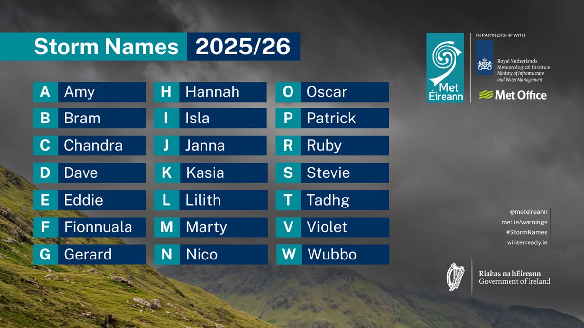
The next named storm system is Bram. The decision to name the next storm rests with the UK Met Office, Met Éireann and the KNMI.
![]()