Updates:
Monday, 12th
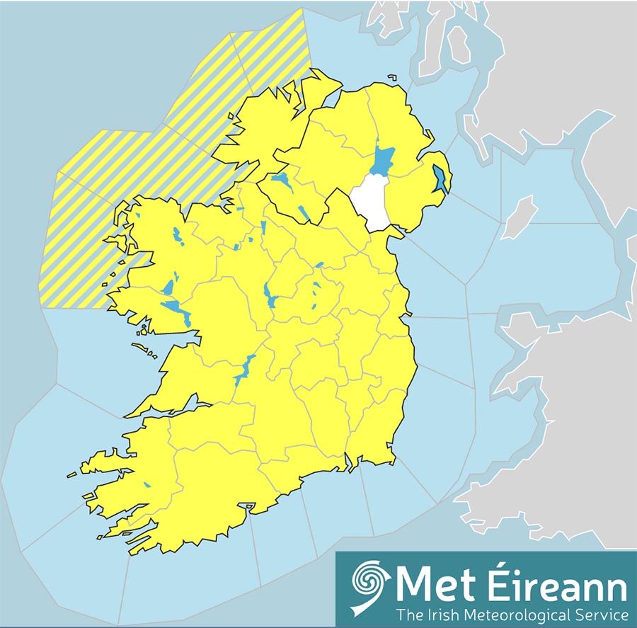
12.45pm – Met Éireann has issued a new Status Orange weather warning for Clare.
The Freezing Fog warning for Connacht and sixteen counties including Clare came into effect at midday.
Met Éireann says there that freezing fog, dense in places, will persist through the afternoon and into tonight, leading to very hazardous driving conditions.
A Status Yellow – Low Temperature/Ice warning is also in place and will remain valid until midday on Friday.
Once the current Status Orange Low Temperature/Ice warning for Ireland expires at midday on Monday, a further Status Yellow alert will take effect and last for the remainder of the week.
Issuing the latest Status Yellow – Low Temperature/Ice warning for Ireland, Met Éireann says it will “remain very cold through the week with widespread sharp to severe frosts and icy stretches.”
The forecaster is also warning of “some showers of hail, sleet and snow will occur, mainly near coasts. Accumulations at lower levels are expected to remain low. Freezing fog will occur at times, with winds remaining light over land.”
Met Éireann is also advising of possible impacts arising from the cold spell including:
• Treacherous conditions on paths and roads
• Travel disruption
• Potential supply disruption
• Potential for burst water pipes and damage to engines
• Increased risks to vulnerable members of the community
• Animal welfare issues
• Slack winds over land leading to reduced wind power generation
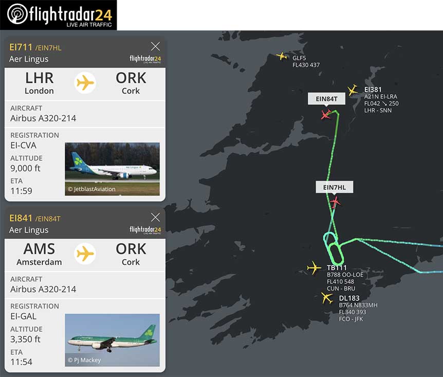
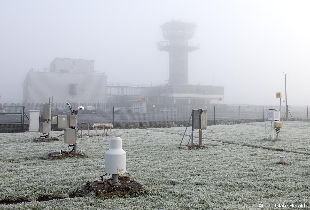
11.30am – While operations at Shannon Airport have not been affected by the weather, the airport has begun to accept flights forced to divert from Cork Airport. Poor visibility and technical issues on the ground in Cork have prevented at least two flights so far from landing.
Aer Lingus flights from Amsterdam and London Heathrow have already diverted to Shannon. Both flights entered holding patterns for sometime north of the airport before the crews opted to diverted to Shannon.
A KLM flight from Amsterdam to Cork has also diverted to Shannon.
A spokesperson for the Shannon Airport Group said: “All air services from Shannon Airport are running to schedule today. Our team has been working 24/7 to ensure the airport’s runway, taxiways and apron remain free from ice and will continue to do so during this cold snap.”
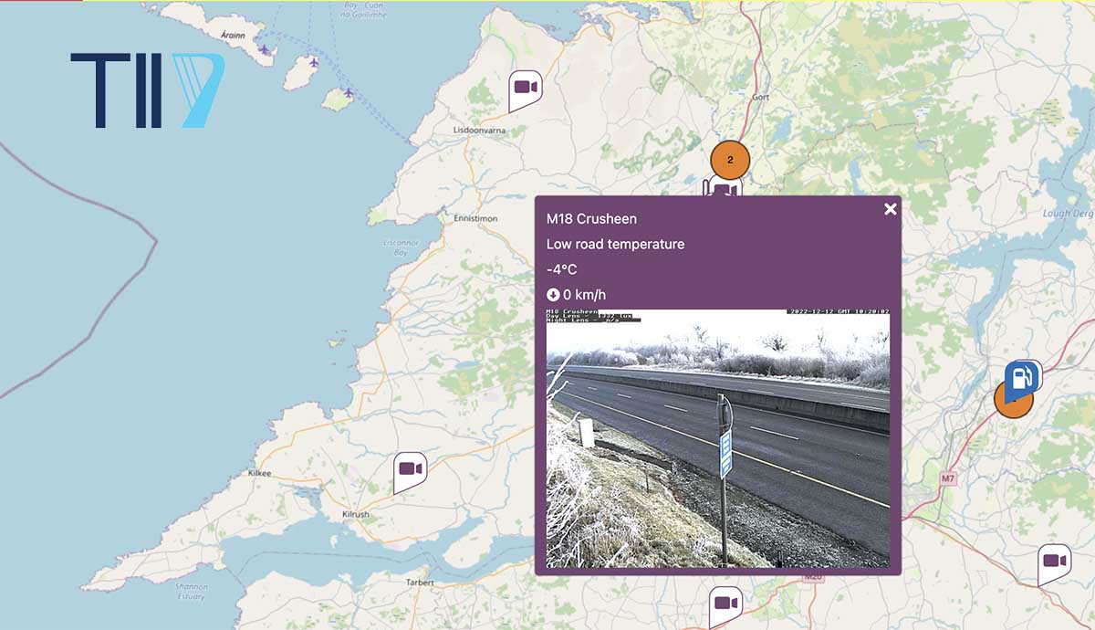
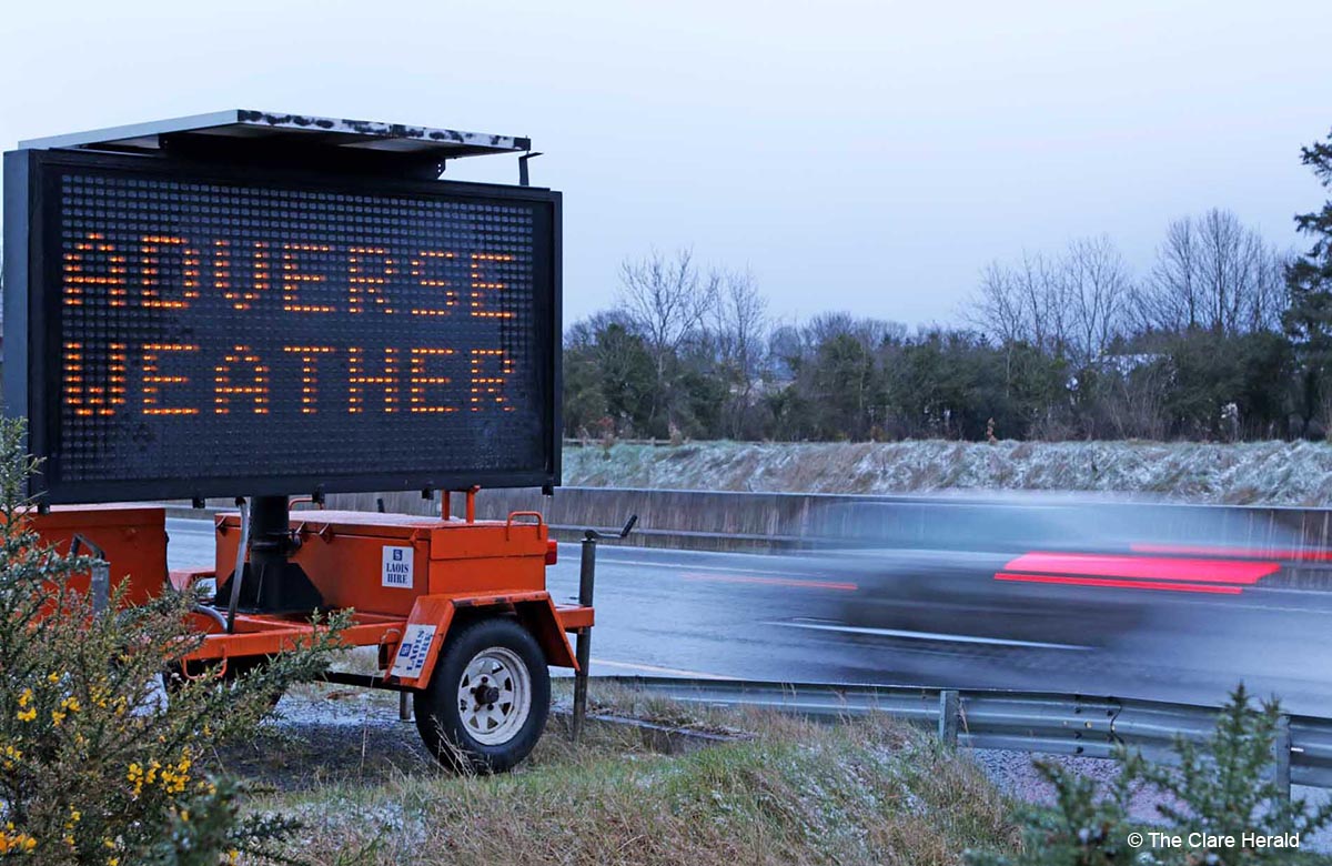
10.30am – Traffic Infrastructure Ireland’s live traffic map is current showing road temperatures on the N18 at Bunratty (-3C); M18 at Crusheen (-4C); N67 at Lisdoonvarna (-3C) and the N68 at Kilrush (-3C)
10.27am – Shannon Ferry Group Ltd has been forced to temporarily suspend sailings again today due to fog. The company is advising intending travellers to check its Facebook page for updates.
10.05am – A Status Yellow – Low Temperature/Ice warning for Ireland will take effect from 12.00pm on Monday (after the Orange alert has expired) and remain valid until midday on Friday.
Once the current Status Orange Low Temperature/Ice warning for Ireland expires at midday on Monday, a further Status Yellow alert will take effect and last for the remainder of the week.
Issuing the latest Status Yellow – Low Temperature/Ice warning for Ireland, Met Éireann says it will “remain very cold through the week with widespread sharp to severe frosts and icy stretches.”
The forecaster is also warning of “some showers of hail, sleet and snow will occur, mainly near coasts. Accumulations at lower levels are expected to remain low. Freezing fog will occur at times, with winds remaining light over land.”
Met Éireann is also advising of possible impacts arising from the cold spell including:
• Treacherous conditions on paths and roads
• Travel disruption
• Potential supply disruption
• Potential for burst water pipes and damage to engines
• Increased risks to vulnerable members of the community
• Animal welfare issues
• Slack winds over land leading to reduced wind power generation
Bitterly cold today🥶 with icy conditions❄️ & freezing fog🌫️ in places, leading to very hazardous travelling conditions⚠️.
Frequent wintry showers🌨️ in W Connacht, with some wintry showers🌨️ later in the E & S.
Temperatures🌡️ of -2 to +4 degrees, coldest in the N midlands. pic.twitter.com/Y6kyL7x5Q9
— Met Éireann (@MetEireann) December 12, 2022
Sunday, 11th
While freezing fog and poor visibility have not affected operations at Shannon Airport, one scheduled outbound and an inbound flight have been cancelled as a result of issues at its destination airport.
Aer Lingus flight EI-380, due to depart for London Heathrow at 7.50am, was cancelled while the inbound EI-381 from Heathrow, due at 11.30am, has been cancelled as a result. It’s understood that the cancellations are due to adverse weather conditions at Heathrow Airport. London is currently subject to a snow and ice warning.
Shannon Airport is advising customers to contact Aer Lingus with queries relating to their flights.
Meanwhile, two Ethiopian Airlines flights that were due to land at Dublin Airport diverted to Shannon early today. The flights from Addis Ababa to Toronto, Canada and Washington in the US continued their journeys later.
Saturday, 10th
6.35pm – Met Éireann has issued a Status Orange – Low Temperature/Ice warning for Ireland.
The weather service has said: “A severe frost and further icy stretches will set in on Sunday night, accompanied by patches of freezing fog. Temperatures likely to fall below -5 degrees in many areas.”
The warning will take effect from 5.00pm on Sunday and remain valid until midday on Monday.
5.25pm – Status Yellow – Freezing Fog warning for Ireland
Met Éireann says pockets of freezing fog are expected, causing potentially hazardous travel conditions.
There is also Status Yellow – Low Temperature/Ice warning in place for Ireland
A sharp frost and further icy stretches will set in on Saturday night as temperatures dip to -5 degrees in places.
Both warnings will remain in place until midday on Sunday.
Friday, 9th
3.10pm – Conditions on the N18 and M18 remain poor this afternoon. Visibility in freezing fog is very poor with road temperatures of as low as -2C being reported on the motorway.
10.48am – Gardaí say no serious incidents have been reported on the county’s roads but caution is still urged.
The head of the Roads Policing Unit in Clare, Inspector Paul Slattery, says motorists should drive to the conditions and be aware that black ice could exist on some roads. The Inspector is urging particular caution on coastal routes where temperatures will struggle to get about 0C this morning.
10.45am – Friday’s forecast
Today
Very cold, and dry for much of the province today with low winter sunshine. Icy stretches, some lying snow, and patches of freezing fog in parts. Temperatures not rising above 0 to 4 degrees, in light northwest or variable breezes.
Tonight
A widespread sharp to severe frost will set in tonight along with icy stretches. While many areas will be dry, some showers of hail and snow will affect coastal areas. Lowest temperatures of -5 to -1 degrees in light westerly or variable breezes.
7.30am – Hazardous conditions and freezing fog reported in many parts of Clare this morning. Road temperatures as low as -4C on the M18 with poor visibility also reported.
Thursday, 8th
5.45pm – Road temperatures are reported to be around 0C on the N18, M18, N68 (Ennis-Kilrush road) and N67 (Lisdoonvarna to Ballyvaughan road). Traffic Infrastructure Ireland (TII) roadside monitoring equipment indicate low road temperatures on these routes. Caution is urged.
-6C on the N68 Ennis to Kilrush road. And I forget my @ClareFM company wollies @PadraicFlaherty #AtlanticTales 😂 pic.twitter.com/cz4UWMxysx
— Pat Flynn (@patsyflynn) December 9, 2022
Thursday’s forecast – An icy start to Thursday with black ice and patches of freezing fog leading to hazardous travel conditions. Further well scattered wintry showers will occur in the morning with a light dusting of snow on some lower levels. Sunny spells will follow as wintry showers become isolated. Highest temperatures of just 1 to 4 degrees in light northerly or variable breezes.
Met Éireann has upgrade a Weather Advisory to a Status Yellow warning for Ireland including County Clare.
The Ice warning will take effect at midnight Wednesday and remain in place until midday on Thursday.
The weather service is warning of hazardous conditions as a band of wintry precipitation sinks southwards with the potential for black ice/freezing rain on surfaces.
Meanwhile, a Status Yellow – Low Temperature/Ice warning has also been issued for Ireland.
The warning will take effect at 10.00pm on Thursday and remain in place until 10am on Friday.
Met Éireann is warning of hazardous conditions with a sharp to severe frost with icy surfaces, as temperatures widely fall to -4 degrees Celsius.
Earlier: Met Éireann has issued a Winter Weather Advisory issued for Ireland.
The weather service is warning of very cold this week as an Arctic airmass sets in, is expected bring sharp to severe frosts and icy stretches on roads.
“Showers of hail, sleet, and snow will occur during the second half of the week. Updates with potential warnings will be issued in the coming days,” Met Éireann has said.
The advisory will remain in place until 11.30pm on Saturday December 10th. Weather warnings could be issued between now and then however.
For winter weather preparation www.winterready.ie
Get your 10-day location forecast at www.met.ie.