
Met Éireann has issued a Status Yellow Wind Warning for Ireland after earlier issuing a Weather Advisory ahead of the arrival of Storm Dave.
Forecasters say: “Storm Dave will bring very strong southerly winds, veering westerly by the evening with severe gusts and coastal gales.
Possible impacts include:
· Some fallen trees, branches
· Wave overtopping
· Difficult traveling conditions
· Debris, loose objects displaced
Originally due to come into effect at 2.00pm on Saturday the Status Yellow Wind Warning will not begin at 1.00pn and has been extended to remain in place until 2.00am on Sunday.
Weather Advisory
Unsettled and mixed over Easter with a mobile Atlantic flow affecting Ireland. Windy or possibly stormy in places later Saturday.
• Potential for some severe or damaging west to southwest gusts.
• Coastal flooding is likely, especially around high tide times and in exposed, low-lying locations along the Atlantic coastal counties.
• High astronomical tides (Spring Tides) coinciding with storm surge and persistent onshore winds will further increase the risk of coastal flooding. Areas along the west and north coasts are particularly vulnerable.
• Strong onshore winds combined with high waves may lead to wave overtopping and flooding in low-lying and exposed coastal areas.
• Warnings are likely to be issued. Stay updated via Met Éireann’s website, app and social media channels.
Forecast
Friday, April 3rd (Good Friday)
Current indications suggest it will turn windy, especially later in the morning and early afternoon, as a developing depression tracks over the country. Current guidance suggests the system will not undergo rapid deepening, but it could still bring some strong winds along with showery outbreaks of rain.
Saturday, April 4th
A wet and windy day with outbreaks of rain, heavy at times with spot flooding possible. There is the potential for some very strong south-westerly winds to occur later in the day, most likely for western and northwestern parts. High astronomical tides (Spring Tides) coinciding with storm surge and persistent onshore winds will further increase the risk of coastal flooding. Areas along the west and north coasts are particularly vulnerable.
Sunday, April 5th (Easter Sunday)
A breezy and showery day. Cooler too and some of the showers will fall as sleet, mainly in the west and north, with the chance of some falls of snow on high ground. Strong onshore winds early on Sunday morning, combined with high waves may lead to wave overtopping and flooding in low-lying and exposed coastal areas.
Monday, April 6th
Potentially another windy day but current indications suggest that the worst of the wind and rain will stay offshore.
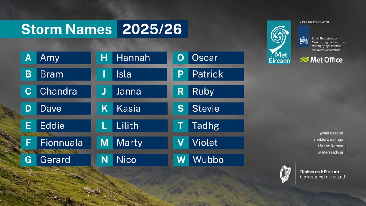
Storms are named when they could cause ‘medium’ or ‘high’ impacts in one of the three partner countries. This enables consistent, authoritative messaging to the public and other stakeholders to help them to prepare for and stay safe during potentially severe weather events.
Since 2015, Met Éireann and the UK Met Office have been working together on the naming programme and were joined by the Netherlands’ KNMI in 2019, to form the ‘western group’ of European weather services.
When a storm is forecast, the national weather service that expects the biggest impact from the severe weather to hit its region, or is likely to be first affected by it, names the storm. Storm naming happens in conjunction with orange/red weather warnings, which could be for wind, rain or snow, or a combination of these conditions. Those warnings are, in turn, issued based on a combination of numerical thresholds and the potential impacts foreseen.